

Switching block KRKUCommunication with GNSS and external systems
+INERTIAL NAVIGATION COMPLEXWith GNSS
MSG-25
Vessel's course and movement
in a unified measurement system.
Rimless inertial system supporting GNSS for marine applications. Generates navigation data and transmits it to external consumers.
ACCORDING TO THE OPERATING MANUAL · VERSION TBAYX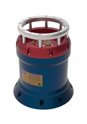
MSG-25ORIENTATION/MOVEMENT
N
↑
COURSE
↑
COURSE
data sheet INDICATORS · MSG-25
- True Course
- ±0,1° / cos φEstablished error of indications, no more.
- Roll · pitch
- 0,008°Error in determining angles, no more.
- Vertical movement
- ±20 mMovement detection range.
- Data output
- 1,000 HzThe upper limit of the output frequency range.
Specifications follow the operation manual. The current documentation and delivery configuration are available on request.
SYSTEM COMPOSITION
Several blocks.
One task.
The manual describes the complex with the main device, switching unit, antennas, computer and cables. Contents depend on delivery.
MAIN UNITGyrocompass MSG-25Block of inertial sensing elements
GNSS antennasTwo remote antennas according to the described configuration
+Software and computer unitSetting, displaying and recording data
+Cables and operating materialsThe composition is specified for a specific delivery
+Specifications follow the operation manual. The current documentation and delivery configuration are available on request.
INTEGRATION ON BOARD
Match the device
with the axles of the ship.
After installation, the system is configured in the coordinates of the object. This helps relate the instrument's measurements to the bow, side, and yaw directions of the vessel.
Ask about installationCOORDINATE SYSTEMSCHEMATICALLY
DATA AND DOCUMENTS
Clear connection.
The documents are nearby.
Do you need specific interfaces, formats and files for integration? We'll tell you which materials suit your design.
INTERFACES SPECIFIED IN THE MANUALThe list for individual blocks and versions needs to be clarified.
Operating manualMSG-25 · revision for review
Request file ↗